GCS developed a parcel and cadastral web mapping application for Lake County, Montana, leveraging the latest ArcGIS Server technologies to streamline access to land ownership data. This powerful tool integrates with popular platforms like Google Maps, Microsoft Virtual Earth, and ArcGIS Server to enhance accessibility for citizens, developers, and government officials. Here’s a detailed look at its features and benefits:

Advanced GIS Web Mapping Solution for Lake County, Montana
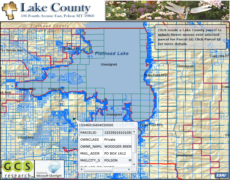
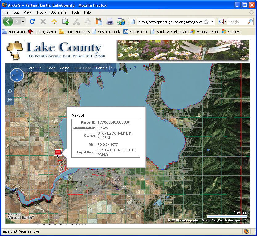
With the introduction of ArcGIS 9.3 and its REST API, GCS utilized Software Development Kits (SDKs) for Google Maps, Microsoft Virtual Earth, and ArcGIS Server to create a mashup of Lake County’s GIS data with global datasets. This allowed the county’s small GIS office to efficiently serve public needs without high personnel costs. Key industries, including property owners, planners, and utility companies, can navigate land data through familiar interfaces.
Key Features of the Lake County Web Mapping App:
1. Interactive Map Interface
- Customizable Map Layers: Users can toggle layers such as land ownership boundaries, parcel numbers, zoning classifications, and property use types. Additional layers include flood zones, protected areas, historical districts, and tax districts.
- Dynamic Basemaps: Users can switch between aerial imagery, topographic maps, and street views to gain a comprehensive understanding of the property’s context.
2. Parcel Search and Advanced Filtering
- Search Capabilities: Find specific parcels by entering parcel ID, owner name, address, or property type.
- Advanced Filters: Filter results by property size, land use category, zoning designations, and assessed value for detailed and relevant searches.
3. Detailed Parcel Information
- Ownership and Deed History: View detailed ownership data, including current owner, deed history, assessment values, and property tax information.
- Legal Descriptions and Plat Maps: Access to legal property descriptions and plat maps provides in-depth property boundaries and dimensions.
- Transaction History: Review past property transactions, including purchase dates, sale prices, and previous owners.
4. Zoning and Development Insights
- Zoning Information: Each parcel includes its zoning designation, helping users understand building restrictions and development guidelines.
- Future Development Layers: A layer showcasing upcoming developments and approved projects offers insights into potential changes in land use.
5. Ownership Change Alerts
- Real-Time Notifications: Users can sign up for alerts about ownership changes, zoning updates, or new property listings to stay informed.
6. Print and Export Features
- Custom Reports: Users can generate reports with maps, ownership data, and parcel information for legal, financial, or planning purposes.
- Export Formats: Data can be exported in PDF, CSV, or shapefiles, enabling further use in other systems.
Benefits of Lake County’s Parcel and Cadastral Web Mapping App:
- Enhanced Transparency and Accessibility: Residents and businesses can easily access land ownership data, fostering trust and informed decision-making.
- Efficient Land Management: County officials can quickly access land records, track ownership changes, and support planning efforts, leading to more effective governance.
- Reduced Resource Demands: The web-based system minimizes the need for in-person inquiries at government offices, saving both time and resources for the public and county staff.
- Improved Decision-Making: Integration with ArcGIS Online allows for in-depth geospatial analysis, supporting future development projects and land use planning.
This web mapping application significantly improves land ownership data management, enhances government transparency, and optimizes development planning in Lake County, Montana. By merging local GIS data with widely used platforms like Google Maps and Microsoft Virtual Earth, GCS has delivered a highly functional, user-friendly solution that supports both public and administrative needs.

About Lake County, Montana: Population, Economy, and Geographic Overview
Located in northwestern Montana, Lake County ranks as the state’s ninth most populated county, with 31,134 residents according to the 2020 U.S. Census. The median household income in Lake County was estimated at $52,493 in 2020, highlighting the economic profile of the area. The county seat, Polson, is the eighteenth largest city in Montana, with a population of 5,148 residents.
Flathead Lake – A Natural Treasure
One of the key attractions in Lake County is Flathead Lake, the largest natural freshwater lake west of the Mississippi River in the United States. Located in Polson, Flathead Lake spans 27.3 miles in length, 15.5 miles in width, and reaches a maximum depth of 370.7 feet. This scenic lake is not only a focal point for the local community but also a popular destination for outdoor enthusiasts and tourists.
Geographic and Environmental Overview
Covering a total area of 1,654 square miles, Lake County boasts a diverse landscape, with 1,490 square miles of land and 164 square miles of inland water. The county’s unique geographic location and its natural resources, like Flathead Lake, make it an ideal area for recreation, tourism, and economic development.
Learn more about the stunning Flathead Lake and what it has to offer visitors and residents alike.
You must be logged in to post a comment.